Indonesia Earthquake Explained: Why the Death Toll Has Risen After the 7.7-Magnitude Flores Quake
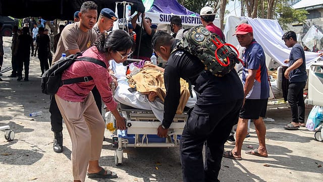
The ground shook before dawn. Houses collapsed on sleeping families. Landslides swallowed roads and isolated entire communities. Hospitals moved patients and oxygen cylinders outdoors as frightened residents refused to return home.
A powerful 7.7-magnitude earthquake struck Indonesia’s Flores region early Saturday, August 15, setting off more than 340 aftershocks and leaving a widening trail of destruction across East Nusa Tenggara province. Indonesia’s National Disaster Management Agency, or BNPB, initially confirmed 47 deaths. By Sunday, the toll had risen to at least 51, with 36 people seriously injured and 77 suffering minor injuries, according to Reuters. Thousands have fled their homes as rescue teams search collapsed buildings and landslide-hit villages. Here is what happened, why the destruction was so severe and whether the other earthquakes recorded across Indonesia were connected.
Where did the deadly earthquake strike?
The earthquake struck at 4.58 am western Indonesian time on Saturday, when most residents were still asleep. Indonesia’s Meteorology, Climatology and Geophysics Agency, or BMKG, placed the epicentre in the sea, around 30 kilometres northeast of Mbay in East Nusa Tenggara. BMKG measured its magnitude at 7.7 and depth at 15 kilometres. The US Geological Survey placed the epicentre approximately 68 kilometres north-northwest of Ende city and estimated a depth of about 10 kilometres. The strongest destruction was reported across Flores Island, particularly in Manggarai, East Manggarai, Sikka, Ende, Ngada and neighbouring regencies.

Flood and Fury
04 Sep 2026 - Vol 05 | Issue 36
Devighat, Nepal, August 29, 2026
Why did the quake cause so much destruction?
Depth made the difference. This was a shallow earthquake, which meant its energy had less distance to travel before reaching the surface. Shallow earthquakes can produce far more intense ground movement near the epicentre than deeper tremors of a similar magnitude. The shaking triggered landslides, collapsed buildings and blocked sections of the Trans-Flores highway. Power failures and damaged communication networks compounded the crisis, making it difficult for rescuers to reach remote settlements. According to The Associated Press, several villages were struck by landslides and thousands of people were forced into shelters or makeshift camps. Many others remained outdoors, too frightened by the aftershocks to return home.
How extensive is the damage?
The scale of destruction has grown sharply as officials have reached previously inaccessible areas. BNPB’s first assessment recorded 157 homes with severe damage, 41 with moderate damage and 148 with lighter damage. It also listed damage to 87 schools, 18 healthcare facilities, six government offices and five places of worship. Updated figures cited by Reuters put the number of damaged homes at more than 1,300. Around 5,000 residents have been evacuated, including more than 3,300 people sheltering in a sports arena and temporary camps in Sikka. Hospitals in several affected areas shifted patients and medical equipment outdoors as a precaution. Power cuts also disrupted fuel supplies, forcing around 20 petrol stations to suspend operations. The numbers remain provisional and could rise as assessment teams enter isolated villages.
Why do reports mention both 47 and 51 deaths?
They reflect different stages of the rescue operation. BNPB reported 47 confirmed deaths in its preliminary update on Saturday evening. At that stage, Manggarai had recorded 24 fatalities and East Manggarai 17, while deaths were also reported in Sikka, West Manggarai, Ngada and Ende. By Sunday, Indonesian officials had raised the death toll to at least 51, according to Reuters. Search teams are still working through collapsed buildings and landslide debris, which means the figure may change again. For a current report, 51 dead should replace the earlier figure of 47, with a clear qualification that the toll remains provisional.
Was there a tsunami?
The earthquake did produce a tsunami, but the waves were considerably smaller than the most dangerous scenarios initially feared. BMKG issued a tsunami warning immediately after the quake. Its monitoring stations subsequently detected sea-level rises at several locations, including a wave of approximately 0.94 metres at Maurole-Ende and 0.36 metres at Labuan Bajo. The agency lifted the warning at around 7.30 am after determining that the threat had passed. The warning was therefore precautionary, but it would be inaccurate to say there was no sea-level rise at all. BMKG’s official monitoring data confirms that small tsunami waves were recorded.
Was Indonesia really hit by three earthquakes within hours?
Yes, strong tremors were recorded in different parts of the country, but they should not automatically be presented as one connected sequence. The devastating magnitude-7.7 earthquake struck near Flores. A strong earthquake was subsequently reported near northern Sumatra, while another magnitude-6.0 tremor was recorded in the Gulf of Tomini. Indonesia stretches across thousands of kilometres and sits above several active tectonic boundaries. Earthquakes occurring within hours of one another can still originate in different fault systems and be geographically unrelated. Around Flores itself, the more immediate threat came from the enormous aftershock sequence. Authorities had recorded more than 340 aftershocks by Sunday, including tremors strong enough to send survivors running from shelters and damaged buildings.
Why is Indonesia so vulnerable to powerful earthquakes?
Indonesia sits on the Pacific “Ring of Fire”, where several tectonic plates meet and move against one another. The Australian Plate is being forced beneath sections of the Sunda Plate, while other complex plate boundaries run through the archipelago. That tectonic pressure makes Indonesia one of the world’s most earthquake-prone countries. Flores has suffered catastrophic earthquakes before. In 1992, a magnitude-7.8 earthquake and tsunami struck the island, killing around 2,500 people. The memory of that disaster helps explain why Saturday’s tsunami warning prompted rapid evacuations from vulnerable coastal areas.
What happens next?
More than 3,500 military and police personnel have joined the rescue and relief operation, according to Reuters. Teams are attempting to clear landslides, reopen roads, restore electricity and deliver food, water, tents and medical supplies to isolated communities. The biggest uncertainty lies beneath the rubble. Officials have not established a definitive number of missing people, and rescuers believe more victims may remain trapped inside collapsed homes or buried by landslides. With aftershocks continuing and access to some villages still restricted, Indonesia’s final toll may take days to emerge.
(With inputs from ANI)