Lake America, Gulf of America & the Global War to Own the Map
Doug Ford arrived beside Lake Ontario wearing a Team Canada football jersey and carrying a sign large enough to be seen from history.
The structure measured 24 feet across and 12 feet high. Raised on six-foot legs near Grimsby, Ontario, its upper edge stood approximately two storeys above the shoreline.
Its message required just four words: LAKE ONTARIO. NOW AND ALWAYS.
Below appeared the French translation: LAC ONTARIO. AUJOURD’HUI ET POUR TOUJOURS. The lake shimmered behind it, seemingly indifferent to the emergency in nomenclature.
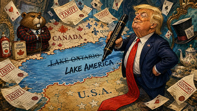
Three days earlier, US President Donald Trump had signed an executive order renaming Lake Ontario as Lake America for American federal use. The order directed the Department of the Interior and the US Board on Geographic Names to update government maps, contracts, databases, documents and communications.
Zeroing In on ECI
09 Oct 2026 - Vol 05 | Issue 41
Constitutional legitimacy versus political opportunism
Ford had brought plywood, steel and Canadian stubbornness. “President Trump can call it whatever he wants,” the Ontario premier said at the unveiling on Saturday. “The rest of the world will always call it Lake Ontario.”
The sign produced an irresistible photograph. It also marked a startling deterioration in one of the world’s closest bilateral relationships. The United States and Canada were already fighting over tariffs, automobiles, dairy, alcohol, steel and access to each other’s markets. Trump had threatened Canada with economic punishment and repeatedly spoken about making it America’s 51st state. Canadian Prime Minister Mark Carney had announced retaliatory tariffs.
Then the trade war entered the atlas. Trump changed a name. Ford erected a sign. A shared lake acquired separate political identities on either side of the water.
A Tariff on Geography
Trump’s order did not disguise the grievance behind the rebranding.
The White House document argued that the United States supplies nine of the 11 icebreaking vessels operating across the Great Lakes, has invested nearly $4 billion in the freshwater system during the preceding decade and derives major economic value from its shipping routes, power generation and ports.
The United States, the order suggested, had protected, maintained and economically developed the lake.
The reward would be naming rights. It read like geopolitical sponsorship. America had paid for the stadium. America wanted its name above the entrance. Trump said the change was connected to Canada’s treatment of the United States on trade and defence. The two countries had failed to complete a trade agreement. Washington subsequently imposed tariffs of 50 per cent on approximately $20 billion of Canadian goods, while Ottawa prepared corresponding measures against American exports.
The lake became another instrument of pressure. Yet the name Trump removed was older than either country. Ontario is derived from an Indigenous word commonly translated as “beautiful lake”, “great lake” or “lake of shining waters”. Carney noted that it had been used for more than 400 years, predating the US Declaration of Independence and Canadian Confederation.
The lake gave the Canadian province its name, rather than the province lending its name to the lake. Indigenous leaders saw more than presidential mischief. Wendat Nation Grand Chief Pierre Picard described the order as an attempt to erase Indigenous history. The Seneca Nation argued that Lake Ontario should not become a political pawn and invoked the 1794 Treaty of Canandaigua, which established peace and recognition between the United States and the Haudenosaunee nations. New York Governor Kathy Hochul also refused to adopt “Lake America”, even though New York is the only US state bordering the lake.
Trump could command Washington’s maps. He could not command Albany, Ottawa, Ontario, Indigenous nations, international organisations or ordinary conversation. The executive order, therefore, produced an unusual cartographic creature: a name official enough to enter the US federal database but powerless to cross the water it describes.
Trump’s Map of American Greatness
Lake America was not an isolated flourish.
On his first day back in the White House in January 2025, Trump ordered the US federal government to rename the Gulf of Mexico as the Gulf of America. He also reversed Barack Obama’s 2015 decision recognising Denali, the Indigenous name for North America’s highest mountain, and restored Mount McKinley.
The three changes reveal a coherent political instinct. Geography is treated as a monument. A name must announce national strength, reward a favoured historical figure or dramatise American possession.
William McKinley never visited the Alaskan mountain that acquired his name during the late 19th century. Trump admires the former president’s enthusiasm for tariffs and has repeatedly invoked him while defending his own protectionist programme. Denali, meaning “the high one” or “the great one” in the Koyukon Athabaskan language, had been used by Alaska Natives for generations. Alaska’s legislature and its Republican US senators opposed Trump’s reversal. The mountain now has one name in the federal system and another in Alaska’s political memory.
The Gulf dispute travelled farther.
Google Maps began showing Gulf of America to users in the United States, Gulf of Mexico to users in Mexico and both names to many people elsewhere. The application did not settle the argument. It geofenced it.
The Associated Press continued using Gulf of Mexico, explaining that Trump possessed authority over US federal terminology but could not unilaterally rename an international body of water. The White House restricted the news agency’s access to certain presidential events, turning a style decision into a dispute over press freedom.
A two-word disagreement affected who could enter the Oval Office. Trump now has a gulf, a mountain and a lake. During the Lake America signing, he joked that an ocean might come next.
Can Half a Lake Be Renamed?
The question sounds comic until one tries to answer it.
There is no global government issuing definitive names for every mountain, sea, river and island. Countries determine official usage within their own administrations. International organisations adopt conventions. Hydrographic agencies standardise nautical references. Publishers and mapmakers exercise their own judgment. Residents retain names that may long predate the institutions attempting to standardise them.
Trump can make Lake America official across federal departments, subject to American law. He cannot compel Canada to use it. He cannot change international practice through an executive order. He cannot force private publishers or digital services to follow.
MapQuest has already said it will retain Lake Ontario. Globe manufacturers have reportedly hesitated, aware that a future administration could reverse the order and leave thousands of expensive spheres politically obsolete.
Paper maps once allowed naming disputes to remain distant. A new edition arrived after years. Digital maps react rapidly and personally.
Google’s stated practice is to use an officially recognised local name when countries disagree and display multiple names in other markets. The result is an atlas that changes according to the user’s location.
Two people can stand on opposite shores of the same water, open the same application and receive different answers to the same question.
The water is shared. The reality is geofenced
India understands that a new name can carry a territorial purpose.
China claims approximately 90,000 square kilometres of Arunachal Pradesh, which it calls Zangnan or South Tibet. Since 2017, its Ministry of Civil Affairs has repeatedly released lists of “standardised” Chinese names for locations inside the Indian state.
The exercises have covered mountains, rivers, lakes, settlements, passes and stretches of land. Beijing has supplied Chinese characters, Tibetan names, Romanised spellings, coordinates and maps.
India has rejected every list.
In April 2026, the Ministry of External Affairs described the latest exercise as an attempt to assign fictitious names, manufacture baseless narratives and disturb efforts to stabilise India-China relations. Arunachal Pradesh, it said, remained an integral and inalienable part of India.
External Affairs Minister S Jaishankar had supplied a simpler rebuttal two years earlier.
If he changed the name of somebody’s house, he asked, would the house become his? A newly assigned name does not transfer military control or legal sovereignty. It enters government records, textbooks, state media, official maps and diplomatic statements. It gives a territorial claim administrative furniture.
Trump’s renaming of Lake Ontario carries no comparable claim to annex Canadian territory. It does, however, inhabit the same broad political tradition: use language to weaken another country’s ownership of the story.
Borders describe control. Names rehearse it.
The Sea Between Japan and Korea
A long-running dispute in East Asia demonstrates how colonial history can live inside a geographical label.
Japan calls the body of water separating it from the Korean peninsula the Sea of Japan. South Korea calls it the East Sea and campaigns for either that name or both names to appear on international maps. North Korea has used East Sea of Korea.
Japan argues that Sea of Japan became internationally established by the early 19th century, before Japanese colonial expansion, and remains the standard used by the United Nations Secretariat and the International Hydrographic Organization’s existing publication on ocean boundaries.
South Korea argues that the name gained international dominance when Korea was under Japanese colonial rule and lacked the sovereign power to object. Its foreign ministry says East Sea has been used on the Korean peninsula for centuries and that increasing dual usage by international mapmakers reflects growing recognition of its case.
The dispute concerns more than direction. For Japan, replacing or diluting the established name would allow contemporary political grievance to rewrite historical cartography. For Korea, retaining it exclusively allows a name consolidated during an age of lost sovereignty to continue speaking for the region.
Both sides have produced historical maps, diplomatic papers and carefully curated timelines. Both contact international organisations and publishers when an unfavourable label appears.
The International Hydrographic Organization has found a technological escape route. Its newer digital standard identifies maritime areas through numerical codes, reducing the need to resolve every politically contested name.
Software can assign a number where history cannot agree upon a noun. Yet humans do not live inside numerical identifiers. They inherit seas through memory, schooling, language and loss. The argument survives.
Persian or Arabian?
Few geographical disagreements can rearrange an entire region with one adjective. Iran insists upon Persian Gulf, a name used across centuries of maps, scholarship and international documentation.
Several Arab governments and organisations use Arabian Gulf or simply the Gulf. “Persian” locates the water within Iran’s civilisational history. “Arabian” shifts its symbolic centre towards the Arab states occupying much of the opposite shoreline.
The competing names carry contemporary strategic rivalry. Iran and the Gulf Arab countries contest regional influence, security, energy routes and relations with the United States. The water between them contains some of the world’s most important oil and gas infrastructure.
An airline, sporting body, media organisation or multinational company can provoke anger merely by selecting one term. Iran has previously protested when organisations removed “Persian” or adopted “Arabian Gulf”. Arab users, in turn, frequently reject terminology that appears to privilege Iran.
The choice may occupy only a few centimetres on a map. It contains centuries.
Falklands or Malvinas?
In the South Atlantic, two names carry an unresolved sovereignty dispute and the memory of a war.
Britain administers the Falkland Islands. Argentina claims the Islas Malvinas.
The countries fought over them in 1982. Britain retained control after the 74-day war, but Argentina never abandoned its claim. The islands’ residents voted overwhelmingly in a 2013 referendum to remain a British Overseas Territory. Argentina does not accept that the vote resolves the sovereignty question.
The United Nations performs its neutrality typographically. It uses Falkland Islands (Malvinas) and records that a sovereignty dispute exists between Britain and Argentina.
The brackets are diplomatic territory. Call them only the Falklands and the language can appear to accept the British position. Call them only Malvinas and it can sound as though the Argentine claim has already prevailed.
The islands remain in the same place. Each name sails under a different flag.
The Country Stopped at the Door by Its Name
Sometimes the argument does not concern a mountain or sea. It consumes an entire country. When the former Yugoslav republic declared independence in 1991, it called itself the Republic of Macedonia. Greece objected.
Macedonia is also the name of a northern Greek region and is inseparable from the historical legacy of Alexander the Great. Athens feared that its neighbour’s choice appropriated Greek history and might imply future territorial claims.
International organisations admitted the country under the provisional label the former Yugoslav Republic of Macedonia. The dispute lasted for more than a quarter-century. Greece blocked its neighbour’s progress towards NATO and complicated its European ambitions.
In 2018, the two countries signed the Prespa Agreement. The state became the Republic of North Macedonia. Greece lifted its objection, and North Macedonia joined NATO in March 2020. NATO itself describes the name question as the principal obstacle that had delayed membership.
The compromise placed one directional word before a national identity. That word opened the door to a military alliance. A name had functioned as a border checkpoint.
When Renaming Restores the Past
Keeping an old name is not automatically an act of historical virtue.
Many names arrived through conquest, empire, cartographic error or the power of outsiders to define places already inhabited by others. Bombay became Mumbai. Madras became Chennai. Calcutta became Kolkata. Ceylon became Sri Lanka. Rhodesia disappeared into Zimbabwe. Swaziland became Eswatini. Turkey asked the international community to use Türkiye.
Some changes recover local pronunciation. Some reject colonial memory. Some consolidate a national identity after political transformation. Others serve the ruling establishment’s ideology.
Denali itself reveals the complication. Trump presented Mount McKinley as the restoration of an American historical name. Alaska Native communities regarded Denali as the older name being displaced again. What Washington calls restoration, Indigenous people may experience as erasure. Lake Ontario makes the conflict even sharper. Trump’s new name contains the youngest history in the argument. Ontario carries an Indigenous origin older than the United States and Canada.
The relevant question cannot simply be whether a name changed. One must ask who possessed the power to choose the earlier name, whose history the new one recovers and which political claim has been folded inside it.
Maps Have Never Been Innocent
Every map makes decisions.
It selects a border, chooses a language, enlarges one place, reduces another and determines whether a disputed line appears solid, broken or absent. It decides which city receives its colonial name, local name or both. It can show Crimea as Ukrainian, Russian or disputed. It can place Arunachal Pradesh inside India while noting China’s claim, or redraw the region according to Beijing’s position.
Online maps personalise those decisions invisibly. A platform may alter borders and labels depending on where the viewer logs in. Governments can demand compliance with local law. Companies can avoid market exclusion by serving different maps to different countries.
The global map has fragmented into national editions without requiring separate printing presses. That gives technology companies an unusual diplomatic role.
Google, Apple and other platforms must decide whether an executive order establishes reality, whether dual naming creates fairness, whether local law overrides international convention and whether a user should be told that another version of the map exists elsewhere.
Their decisions reach more people than most government atlases. Trump’s Lake America order therefore creates a test extending beyond Canada and the United States. Will the world’s largest mapmakers reproduce the new name? Will they display both? Will the answer change when a user crosses the border? Will news organisations accept Washington’s terminology? Will school textbooks follow? A president can sign a name into the federal database in seconds. A name becomes real only when other mouths begin to use it.
Who Owns the Lake?
Trump possesses the executive order. Ford possesses the giant sign. Carney possesses 400 years of etymology. The Wendat and Seneca possess histories extending beyond both modern countries. New York possesses the American shoreline and refuses the new name. MapQuest possesses the freedom to say no. Google and Apple possess screens through which billions of people encounter geography. The public possesses habit.
These are different kinds of power. Some names succeed because the state can enforce them across schools, road signs, passports, institutions and public records. Others prevail because residents already use them. Some remain disputed for generations. A few die immediately after the politician who invented them leaves office.
Ford predicted that Lake Ontario would outlast Trump. He is almost certainly right about the water. The name is now the battlefield. On the Canadian shore, the two-storey sign declares LAKE ONTARIO. NOW AND ALWAYS.
Across the same water, American federal maps are preparing to print LAKE AMERICA. The waves will cross the international boundary without checking which country’s database has named them. Same lake. Same water. Two governments competing for the last word.
With inputs from ANI