Google Says ‘Lake America’. Apple & MapQuest Say ‘Lake Ontario’. Which Map is Telling the Truth?
Doug Ford built a 24-by-12-foot sign beside Lake Ontario. Donald Trump found a larger billboard: every American phone. The Ontario premier’s structure, planted along the Canadian shoreline in Grimsby, declares “Lake Ontario. Now and Always” in English and French. It is big, bilingual and deliberately defiant. Ford wants anyone looking across the water to understand that an executive order signed in Washington cannot erase four centuries of history.
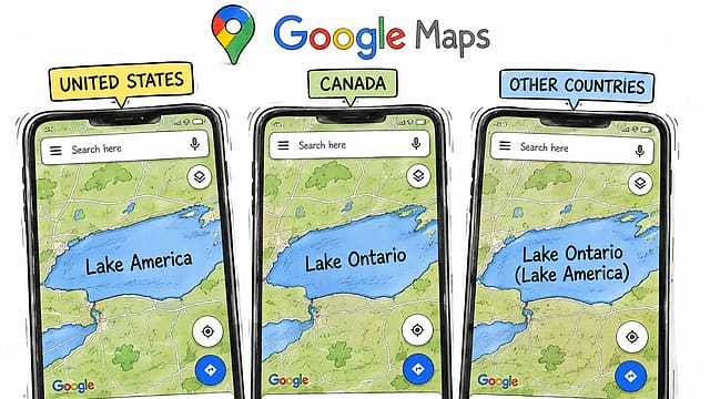
Open Google Maps in the United States, however, and Lake Ontario has disappeared. It has become Lake America. Open the same application in Canada and Lake Ontario returns. Open it somewhere else and Google displays both names: Lake Ontario (Lake America).
One lake. Three labels. Three versions of political reality, selected according to where Google believes the user is located.
Zeroing In on ECI
09 Oct 2026 - Vol 05 | Issue 41
Constitutional legitimacy versus political opportunism
Trump’s executive order may have started the fight, but Google has given it scale. The US president legally changed the terminology used by his federal government. The world’s most powerful mapping platform converted that administrative decision into personalised geography.
The lake has not moved. The border has not changed. The water remains shared by two countries. Only the user has moved. And the truth on the screen has moved with them.
How Did Lake Ontario Become Lake America?
Trump signed an executive order on August 27 directing the US Department of the Interior and Board on Geographic Names to replace “Lake Ontario” with “Lake America” in the Geographic Names Information System, or GNIS.
The order describes the lake as vital to American shipping, manufacturing, power generation and employment. It also credits the United States with supplying nine of the 11 icebreakers operating across the Great Lakes.
In Trump’s version, renaming the lake recognises the American investment and protection that sustain it.
The political trigger was less ceremonial. Trump issued the order as US-Canada trade negotiations disintegrated and Washington imposed 50% tariffs on billions of dollars’ worth of Canadian products. Canada announced matching retaliation. Trump accused it of exploiting the United States, said he did not want “Canadian anything” and again complained that the country expected to be treated like an American state.
The lake became another instrument of pressure. Trump’s order requires American federal maps, databases, contracts, documents and official communications to use Lake America. It cannot force Canada, international institutions, US state governments or private companies to accept the change.
New York Governor Kathy Hochul, whose state borders the lake, rejected the new name. Canadian Prime Minister Mark Carney pointed out that Ontario comes from the Wendat word Ontari’io and predates both Canadian Confederation and the US Declaration of Independence. “Canadians also know that naming reality means calling it Lake Ontario, then, now and always,” Carney said.
Trump could instruct Washington to speak differently. He could not compel everyone else to listen. Then Google listened.
Google Did What Trump Could Not
Google said it changed the name after the US Geographic Names Information System formally adopted Lake America.
“Since we update Google Maps to reflect name changes in official government sources, like GNIS, people using Maps in the US will see ‘Lake America’, those in Canada will continue to see ‘Lake Ontario’, and those outside of the US and Canada will see both names,” the company said.
Google describes this as a long-standing policy for bodies of water whose names vary between countries. It used the same approach after Trump renamed the Gulf of Mexico as the Gulf of America in 2025.
But there is a substantial difference between translating a name and localising a political claim.
“Lake”, “lac” and “lago” are different linguistic routes to the same geographical destination. Lake Ontario and Lake America carry rival accounts of history, authority and national ownership. Displaying one or the other does not simply help a user understand a map. It chooses which government’s political language occupies the screen.
Google says the name shown in its Maps application is determined by a user’s country location. On mobile phones, that can be inferred from the operating system, SIM card, network and locale. On the web, Google can use the region selected in Search settings or the device’s location.
In practical terms, an invisible collection of technical signals now determines what one of the Great Lakes is called. An American can stand on the southern shore and see Lake America. A Canadian looking across the same water sees Lake Ontario. An Indian user is presented with both and asked, implicitly, to carry the argument. This is cartography by geolocation.
Maps Have Always Been Political. Google Made Politics Personal
Maps have never been neutral drawings of the Earth. Governments have used them to assert borders, legitimise territorial claims and make political aspirations appear geographical. A solid line can imply settled sovereignty. A dotted line can advertise disagreement. A name printed in large letters can make a claim feel older and more permanent than it is.
The digital map has made that power less visible and more intimate.
A printed atlas generally offers one representation to all its readers. Google Maps can show different borders and names to users in different countries. Disputed territories, contested coastlines and politically sensitive place names can therefore change without the physical landscape changing at all.
Google calls this localisation. Governments may see it as compliance. Critics can reasonably describe it as the fragmentation of shared reality.
The Lake Ontario episode is especially revealing because the underlying international boundary is not disputed. Canada and the United States agree where one country ends and the other begins. The Boundary Waters Treaty has governed cooperation over their shared waters since 1909.
The argument concerns the name of the water spanning that accepted border. Trump’s order acknowledges that the lake is bounded by both New York and Ontario. It nevertheless replaces an Indigenous-derived, centuries-old name with one carrying the national identity of only one of the countries sharing it.
Google then makes that unilateral claim appear official to users in the larger technology market. The company has not changed the international border. It has changed the political atmosphere hovering above it.
Apple and MapQuest Expose the Choice
Google’s response might appear automatic: GNIS changed, so Google Maps changed.
The conduct of its competitors shows that it was still a choice. Apple Maps continued to identify the body of water as Lake Ontario for American users as of Sunday, according to reports. MapQuest was even more direct. “We’re not changing it,” the company declared on social media.
Waze also continued showing Lake Ontario at the time, even though Google acquired the navigation company in 2013. If that remains unchanged, users can encounter two names for the same lake across services controlled by the same corporate parent.
These differences expose an important fact. Digital mapmakers are not merely pipes carrying government data. They have policies, editorial standards and considerable discretion over how competing names are presented.
National Geographic’s map policy, for instance, says multinational geographical features should generally follow widespread international usage and that names must be checked against several sources, including governments, the United Nations and international bodies.
Google prioritised the newly updated American database for American users. Apple had not followed. MapQuest refused. Three companies received the same presidential order. They produced different Americas.
When Trump’s Map Crossed Into Canada
The most delicious complication appeared on the side of the border rejecting the change.
Some Ontario government and agency webpages using embedded Google mapping technology reportedly began displaying Lake America. The provincial government began reviewing its websites after the label appeared on pages associated with Ontario institutions, including the Liquor Control Board of Ontario, according to Reuters.
Ford could erect a giant sign defending Lake Ontario. Carney could invoke Indigenous history. Canadian institutions could refuse to recognise Trump’s order. Yet an American technology platform embedded inside Canadian digital infrastructure could carry Trump’s terminology back across the border.
That is the deeper sovereignty story. Governments increasingly depend on private platforms for maps, cloud services, search, communication and public-facing digital tools. When the platform changes a label, the alteration can ripple through websites and applications that never made the same political decision.
Canada owns its position on the lake’s name. It may not fully control how that position appears across the technological systems it uses.
Trump’s cartographic order, therefore, acquired an authority it did not possess in law. Google did not give the president sovereignty over Canadian water. It gave his preferred terminology distribution, repetition and the visual legitimacy of a familiar blue-and-green map.
Trump’s Cheapest Weapon
Trump understands the politics of naming unusually well. Renaming a landmark costs less than imposing a tariff, deploying a ship or negotiating a treaty. It produces immediate headlines, angers an opponent, energises supporters and creates a visible monument to presidential power.
It also forces institutions to choose. Government agencies must comply. Governors can resist. News organisations must decide which name enters their copy. Technology companies must decide which database becomes reality on their products.
After Trump renamed the Gulf of Mexico, the Associated Press continued using the historical name while acknowledging the new American terminology. The White House subsequently restricted the news agency’s access to certain presidential spaces, triggering a legal confrontation over government retaliation and editorial independence.
The Lake Ontario dispute extends the same battle into navigation. Trump does not require Canada or the world to accept Lake America permanently. Every argument over the name keeps his formulation alive. Every screenshot distributes it. Every company that adopts it turns presidential theatre into routine digital experience.
He has converted cartography into culture war.
Can Trump Actually Rename Lake Ontario?
The simplest answer is: only within the authority of the US federal government.
He can direct federal agencies to use Lake America and order the relevant American database to carry that name. He cannot alter Canadian usage, compel New York to change its terminology, rewrite the Boundary Waters Treaty or require international mapmakers to follow him.
But legal authority is only one form of power. Google Maps is used to navigate roads, locate businesses, explore borders, plan journeys and understand places. When it adopts an official name, that name begins appearing in searches, screenshots, embedded maps and everyday conversation.
Trump could not rename the entire lake. Google could make millions of people feel that he had. The argument now extends beyond Lake Ontario and even beyond Trump. As maps become personalised, the same mountain, sea, border or territory can acquire a different political identity on different phones.
A map once claimed to show the world. Google Maps increasingly shows the world that a government, database and platform have jointly selected for you. Doug Ford’s giant sign may remain beside the water long after Trump leaves office. But Trump has already secured the more powerful surface. The screen in your hand.
(With inputs from ANI)