THE NEPAL EFFECT | Is India Ready for the Next Himalayan Glacial Lake Outburst Flood?
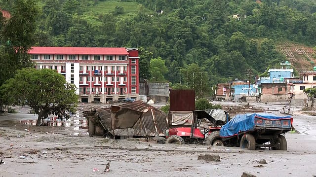
The mountain broke at 9:34 in the morning.
High above the Nepal-Tibet border, a mass of ice and rock detached from a glacier and thundered down the slope. It struck the valley with sufficient force to send water, mud, boulders and shattered ice racing through the Bhote Koshi and Trishuli river corridors.
Villages vanished. Bridges were ripped away. Hydropower projects were damaged. Thousands of homes were destroyed or made uninhabitable. The dead were recovered far downstream. Search teams began digging through millions of tonnes of debris and entering hydropower tunnels in which hundreds were feared trapped. The flood moved faster than the warning.

The Health and Wellness Issue
25 Sep 2026 - Vol 05 | Issue 39
Eight days later, Union Home Secretary Govind Mohan called Himalayan states, disaster authorities and scientific agencies into a review meeting in New Delhi.
The subject was India’s preparedness for glacial lake outburst floods and snow avalanches. The Ministry of Home Affairs did not explicitly say that Nepal’s August 26 catastrophe triggered the meeting. The timing nevertheless supplied the room with its most powerful presentation.
Nepal had already shown what failure could look like. Now India wanted to know whether its satellites, sensors, officials, evacuation plans and ₹150-crore mitigation programme could prevent the same sequence from crossing the Himalayas.
The Nepal Effect
The Home Secretary asked Uttarakhand, Himachal Pradesh, Sikkim, Arunachal Pradesh and Jammu and Kashmir to maintain “continuous and proactive monitoring” of vulnerable glacial lakes and avalanche-prone areas.
The meeting examined early-warning systems, high-risk locations, possible flow paths, evacuation readiness, last-mile communication and the deployment of response forces. States were told to identify gaps and correct them before an extreme event. The mitigation projects approved by the Centre in 2024 must be accelerated.
These instructions sound sensible. They also sound unfinished.
India has endured repeated Himalayan disasters, including the 2013 catastrophe in Uttarakhand, the 2021 Chamoli flood and the 2023 South Lhonak lake outburst in Sikkim. Each produced investigations, new assessments and renewed calls for better warnings. A national GLOF mitigation project was approved after Sikkim. Two years later, in the shadow of Nepal, the Centre is asking states to expedite it.
That is the uncomfortable Nepal effect. A catastrophe across the border has turned India’s preparedness plan into an urgent question: how much has moved since the previous catastrophe?
Nepal Was More Than a GLOF
The precise cause of the Nepal disaster remains under scientific examination. Initial descriptions called it a possible glacial lake outburst flood. Subsequent satellite and seismic analysis pointed towards a massive ice-rock avalanche or glacier collapse in Tibet that generated a catastrophic debris flow downstream.
The World Meteorological Organization said preliminary reports indicated that an avalanche of ice and rock near the border triggered the flash floods. This distinction matters. A classical GLOF begins when water stored in or around a glacier suddenly breaches an ice dam, moraine wall or other natural barrier. Nepal’s disaster appears to have started with a collapsing mass of glacier, ice and rock.
But the risks overlap. An avalanche can strike a lake and displace its water. A landslide can block a river and create a temporary lake. That barrier can then fail, producing another flood. A glacier collapse can generate a debris flow without requiring an established glacial lake to burst.
One failure can create the conditions for the next. After the first Nepal flood, debris reportedly dammed water near the border and created a barrier lake, forcing evacuations over fears of a second disaster. This is why the Indian review combined GLOFs and avalanches. The next Himalayan catastrophe may refuse to fit neatly inside one bureaucratic category.
What Is a Glacial Lake Outburst Flood?
As a glacier retreats, meltwater can collect behind loose rock, sediment or ice. Some of these lakes are held in place by natural walls called moraines, built from material carried and deposited by glaciers.
They are not engineered dams. Their shape, strength and stability can change. A period of intense rain may raise the water level. An avalanche, landslide or falling block of ice can enter the lake and generate a displacement wave. Melting ice or thawing permafrost can weaken the surrounding structure. Water may gradually cut through the barrier until the breach suddenly widens.
Then the lake releases. The first surge gathers mud, trees, boulders and wreckage as it descends. A flood of water becomes a moving mass of debris capable of destroying roads, bridges, power stations and settlements. The lake may be located in a remote and thinly inhabited area. The destruction can arrive many kilometres downstream. That geographical separation makes GLOFs especially treacherous. The community being killed may never have seen the lake that killed it.
The Himalayas are warming, glaciers are retreating and many glacial lakes are expanding.
An ISRO analysis of satellite imagery from 1984 to 2023 examined 2,431 lakes larger than 10 hectares across Himalayan river catchments. It found that 676 had expanded significantly. Of these, 130 were located within India: 65 in the Indus basin, seven in the Ganga basin and 58 in the Brahmaputra basin.
A growing lake is not automatically a lake about to burst. Risk depends on its volume, surrounding slopes, dam composition, downstream exposure, possible avalanche paths and many other variables. Expansion increases the need to investigate.
Satellites can measure changing lake area, detect the appearance of new water bodies and compare decades of images. Field teams can then use drones, bathymetric surveys, weather stations, water-level sensors and geological studies to estimate depth, volume and structural stability.
India is no longer blind to its glacial lakes. Its next challenge is converting visibility into warning.
Nearly 200 High-Risk Lakes
The National Disaster Management Authority has reportedly classified nearly 200 Indian glacial lakes as high risk.
Earlier published distributions placed 48 in Himachal Pradesh, 40 in Sikkim, 35 in Ladakh, 28 in Arunachal Pradesh, 26 in Jammu and Kashmir and 13 in Uttarakhand. These numbers can change as inventories and risk models are updated. The classification itself is only the beginning.
A satellite picture can show that a lake is expanding. It cannot always establish its depth, the strength of the moraine holding it, the stability of the slopes above it or the exact path a breach will take.
That requires people to reach the lake. The terrain makes field assessment expensive and dangerous. High-altitude windows are short. Weather can close access. Equipment must survive snow, ice, falling rocks and months without maintenance. Some lakes sit near international borders where physical access and data sharing become strategic issues.
The water does not respect those borders. A flood originating in Tibet can enter Nepal. A Himalayan lake outside India can threaten an Indian river system. An upstream warning may depend on another country noticing the danger and sharing the information quickly.
Nepal is now seeking stronger real-time cooperation with China after a disaster that began across the border. India faces the same transboundary Himalayan reality.
₹150 Crore Against the Mountain
The Centre approved the National Glacial Lake Outburst Flood Risk Mitigation Project in July 2024.
The programme covers Arunachal Pradesh, Himachal Pradesh, Sikkim and Uttarakhand, with a total outlay of ₹150 crore. The Centre was to provide ₹135 crore through the National Disaster Mitigation Fund, while the four states would contribute ₹15 crore. Its stated objectives include preventing deaths, limiting economic and infrastructure damage, strengthening monitoring and early-warning capacity, improving last-mile communication and supporting scientific risk reduction.
The Centre released initial instalments of ₹1.83 crore to Arunachal Pradesh and ₹8.35 crore to Sikkim in October 2024. A government review later recorded ₹27.87 crore in central assistance for GLOF projects in Arunachal Pradesh, Himachal Pradesh and Uttarakhand during 2025.
The disclosures do not, by themselves, provide a complete public picture of expenditure, physical progress or lake-level coverage across the four states. The Home Secretary’s instruction to expedite the projects shows that implementation remains a live concern.
The amount also invites perspective. ₹150 crore spread across four states, hazardous expeditions, scientific surveys, sensors, communication networks, engineering works, evacuation systems and community training is a beginning. It cannot protect the entire Indian Himalaya.
Nor does the programme formally cover every Himalayan region carrying risk. Jammu and Kashmir attended the latest review, but it was not among the four states included in the 2024 project. Ladakh did not appear in ANI’s list of participating administrations, although earlier assessments reportedly placed 35 high-risk lakes there.
A national threat is being addressed through a project with a selective map. The government must explain how high-risk lakes outside those four states and across international borders fit into the protection architecture.
Lessons From South Lhonak
India does not need Nepal to understand a GLOF. On October 3, 2023, the South Lhonak glacial lake in Sikkim breached and sent a devastating flood down the Teesta valley.
The surge struck the Teesta III hydropower project, destroyed its dam and damaged roads, bridges, military facilities and settlements. People were killed and many went missing. South Lhonak had been studied before the disaster. Scientists had documented the lake’s expansion and warned about its vulnerability.
Knowledge existed. Protection did not arrive in time. The episode exposed the difference between identifying a hazardous lake and maintaining a complete warning chain. Risk assessments must lead to instruments at the lake, robust communications, designated decision-makers, alerts understood by residents and rehearsed routes to higher ground.
If any one link fails, the warning can die between the glacier and the village. The flood will not.
Can Early Warning Actually Work?
A functional system begins upstream.
Water-level sensors measure rapid changes. Automatic weather stations track rainfall and temperature. Cameras provide visual confirmation. Seismic instruments may detect avalanches or sudden mass movement. Satellite links transmit data when mobile and terrestrial networks fail.
Software analyses the signals and flags abnormal behaviour. Then the human chain begins. A monitoring centre must receive the data. An authorised official must decide whether the threshold requires an alert. District administrations, police and disaster-response teams must act. Sirens, mobile warnings, radio, satellite phones and village volunteers must carry the message downstream.
People must know what the siren means. They must know where to go. The route must remain usable at night, in rain and during a power or telecommunications failure. Elderly residents, children, tourists, migrant workers and people with disabilities must be included in the plan.
Animals and essential medicines may need to be moved. Hydropower operators must know when to evacuate tunnels and sites. Roads cannot be allowed to carry traffic into the flood path after the warning is issued.
Technology may supply minutes. Preparedness determines what those minutes are worth. Nepal’s experience shows how fragile the chain can be. Monitoring stations can themselves be destroyed. Regular river gauges may not recognise the signal generated by an ice-rock avalanche. Networks can collapse. An upstream event may unfold inside another country.
A system designed only for the disaster officials expect may fail when the mountain invents another one.
The Last-Mile Test
India already possesses multiple scientific institutions working on parts of the problem.
The Central Water Commission monitors glacial lakes and water bodies. ISRO supplies satellite analysis. The India Meteorological Department tracks weather. The Defence Geoinformatics Research Establishment studies snow and avalanche risks. NDMA coordinates mitigation. State and district authorities are responsible for acting on warnings.
The institutional alphabet is impressive. The flood encounters a village. The Home Secretary’s emphasis on last-mile dissemination is therefore crucial. A hazard map stored in a government file cannot save anyone. Neither can an alert arriving after the bridge has disappeared.
India’s cyclone-warning system improved dramatically when forecasting was combined with mass evacuation, shelters, repeated drills, local administration and clear public communication.
The Himalayas are harder. Hazards are smaller in geographic footprint, more varied in origin and often much faster. Settlements and infrastructure are scattered through narrow valleys. Escape may mean climbing immediately rather than travelling to a distant shelter.
That makes community knowledge indispensable. Residents must be treated as participants in the warning system, not merely recipients of a message from Delhi.
Hydropower in the Flow Path
The Himalayan development model complicates the risk. River valleys carry roads, tunnels, bridges, military logistics, pilgrimage routes and hydropower projects. The same narrow geography that channels water for electricity also channels a GLOF or debris flood towards infrastructure.
Hydropower projects can become victims and force multipliers. A flood may damage a dam, release additional water, block tunnels, trap workers and send broken concrete and machinery downstream. Construction debris and poorly managed spoil can add to the destructive load.
This does not make every Himalayan hydropower project inherently unsafe. It makes credible hazard modelling, cumulative-impact assessment and emergency planning non-negotiable.
Projects must be designed against plausible future extremes, including cascading events that historical river records may not capture.
Yesterday’s flood cannot remain the engineering limit in a rapidly changing cryosphere. Some high-risk lakes may require physical intervention. Depending on terrain and technical feasibility, authorities can consider controlled lowering of water levels, reinforced outlets, drainage channels, stabilisation measures or barriers designed to reduce the impact of waves created by falling ice and rock.
Such work is extremely sensitive. Poorly designed intervention can destabilise the lake it is intended to secure. Heavy equipment may be impossible to transport. Construction can damage fragile terrain. Every solution must be tailored to the lake rather than copied from a standard manual.
In many locations, the most practical protection may lie downstream: restrict construction in the flow path, redesign vulnerable infrastructure, establish automatic warnings and create evacuation routes.
That demands an unpopular form of governance. Authorities must sometimes tell people and developers where they cannot build. India is more comfortable responding to Himalayan disasters than denying permission before them. The mountain sends the bill later.
The September meeting produced the correct vocabulary. Continuous monitoring. Risk-informed planning. Preventive mitigation. Inter-agency coordination. Community preparedness. Timely dissemination. District-level action.
The test begins after the meeting ends.
Which lakes will receive instruments, and by when? Which downstream settlements have mapped evacuation routes? How many sirens are operational? Who monitors the systems through winter? Which authority can order an evacuation across district boundaries? How will India receive upstream information from neighbouring countries? What progress has each state made under the ₹150-crore programme?
And why did a project approved after Sikkim require another acceleration order after Nepal?
These are measurable questions. Preparedness should produce measurable answers.
Before the Mountain Breaks
Nepal is still counting its dead. Rescue workers are moving through debris, broken settlements and dark hydropower tunnels. Thousands of families face displacement. A cross-border glacier collapse became a national catastrophe within minutes.
India cannot describe the event as somebody else’s disaster. The same warming mountain system stretches across national boundaries. Glacial lakes are expanding. Ice and rock are becoming unstable. Roads, power projects and settlements continue to occupy narrow valleys downstream.
The Home Secretary’s review is therefore necessary. Its necessity is also an indictment. India has the satellites to watch lakes grow. It has scientists capable of modelling a breach. It has agencies that can map the flood path and technology that can transmit an alert from extreme altitude.
What remains uncertain is whether all those capabilities can become one working chain before the water begins moving. Nepal has shown what happens after the mountain breaks. India’s meeting will matter only if it changes what happens before it does.
With inputs from ANI & agencies