EOS-05 LAUNCH | India’s First Geo-Imaging Eye Begins Its 36,000-km Climb
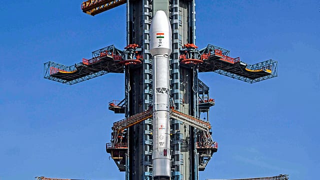
For 307 seconds, India’s first eye in the sky appeared to be heading towards the stars. Then the screen changed.
On August 12, 2021, GSLV-F10 had risen from Sriharikota carrying EOS-03, a satellite designed to give India something it had never possessed: a dedicated imaging platform capable of repeatedly watching the subcontinent from geosynchronous orbit.
The rocket’s first stage performed normally. So did the strap-on boosters.
The second stage completed its work. Then, 297.3 seconds after lift-off, pressure inside the cryogenic upper stage began behaving abnormally. Ten seconds later, the onboard computer aborted the mission.
The third stage never ignited. EOS-03 fell back towards Earth carrying an unfinished ambition with it.

Losing Memory
16 Oct 2026 - Vol 05 | Issue 42
The making of a medical and social emergency
Five years later, another GSLV stood on the same coast carrying the replacement. At 2:55 am on Friday, GSLV-F17 illuminated the darkness above Sriharikota. Rain had failed to disperse the students, teachers and space enthusiasts gathered in the viewing gallery.
The rocket rose. This time, the cryogenic stage fired. Around 18 minutes after launch, EOS-05 separated into its intended sub-geosynchronous transfer orbit. India’s lost eye had returned to the sky.
The Mission Is Not Over
The launch succeeded. The journey has not finished.
Contrary to early reports saying EOS-05 had been “deployed in geosynchronous orbit”, the Indian Space Research Organisation said GSLV-F17 placed the spacecraft in a sub-geosynchronous transfer orbit.
The distinction matters. According to ISRO’s mission brochure, the rocket was designed to release the satellite into an elliptical orbit with a nominal low point of 170 km and a high point of 28,934 km.
EOS-05 must now use its own propulsion system to perform a series of orbit-raising manoeuvres. These burns will gradually lift and circularise its path before the spacecraft reaches its operational position.
Then its systems must be tested. Its solar arrays, communications, guidance and imaging payloads must function as intended. Only after commissioning can EOS-05 begin delivering operational images.
GSLV-F17 has completed its assignment. EOS-05 must now complete the climb.
Why 36,000 km Changes the View
Most Earth-observation satellites operate in low-Earth orbit, only a few hundred kilometres above the planet.
That proximity allows them to produce highly detailed images. But the satellite is moving rapidly relative to the ground. It sees a location when its orbital path carries it overhead, then disappears until the next suitable pass.
EOS-05 is designed for a radically different vantage point. A spacecraft in geosynchronous orbit travels around Earth at the same rate that Earth rotates. When positioned appropriately, it can repeatedly observe the same broad geographical region from approximately 36,000 km away.
Low-orbit satellites fly over the story. EOS-05 can remain with it.
Reports indicate that the spacecraft is intended to scan the Indian landmass at intervals of approximately 30 minutes and revisit selected locations within about five minutes, depending on operational requirements and viewing conditions.
That changes what India can watch and how quickly it can return its gaze.
A cyclone can be followed as it evolves. A wildfire can be revisited before it has moved far beyond the previous image. Floodwater, smoke, crop stress, forest change, coastal activity and other large-scale events can be examined repeatedly instead of waiting for another orbital pass.
For strategic surveillance, persistence is as important as detail. A single image shows where an object was. Repeated images begin to show what it is doing.
India’s First Dedicated Geo-Imaging Eye
India already operates weather and communication satellites in geostationary orbit. INSAT spacecraft have carried meteorological imagers capable of observing clouds, storms, water vapour and other atmospheric conditions. EOS-05 is different in purpose and configuration.
ISRO describes it as India’s first imaging satellite from geosynchronous orbit. More precisely, it is India’s first dedicated Earth-imaging spacecraft intended to provide frequent, multispectral and hyperspectral observations from that high orbital position.
The qualification matters because India has photographed Earth from geostationary platforms before.
What EOS-05 adds is an observation architecture designed around repeated imaging of land and ocean targets rather than primarily meteorological services.
Its instruments are expected to observe across visible, near-infrared and short-wave infrared wavelengths. Multispectral imaging records selected bands of the electromagnetic spectrum. Hyperspectral imaging divides that spectrum into many narrower bands, allowing analysts to distinguish materials and conditions that may look identical in an ordinary photograph.
A healthy crop, a stressed crop and dry soil may produce different spectral signatures.
So can minerals, vegetation, water, smoke and certain types of surface change. EOS-05 is, thereforev more than a camera. It is intended to read the colour of the planet beyond the colour visible to the human eye.
The Eye Still Has a Blind Spot
The phrase “24x7 surveillance” makes for a dramatic headline.
It also requires a caveat. EOS-05 can remain available to observe the same region continuously. That does not mean it can always see the ground.
Visible and infrared imaging can be obstructed by clouds. This becomes particularly important during the monsoon, when floods and landslides may occur beneath the very cloud systems hiding the terrain.
The satellite’s high orbit also creates an unavoidable trade-off. At approximately 36,000 km, it can watch an enormous area persistently. But it cannot ordinarily match the fine spatial resolution of an optical satellite flying only a few hundred kilometres above Earth.
EOS-05 trades proximity for persistence.
That is why it complements India’s low-orbit imaging satellites and radar platforms rather than replacing them.
The NASA-ISRO Synthetic Aperture Radar satellite, NISAR, can observe the surface through clouds and darkness and detect subtle changes in land, ice and vegetation. But as a low-orbit spacecraft, it must wait for its path to bring it back over the same location.
NISAR can see through the cloud but must return with its orbit.
EOS-05 can keep returning its gaze but may find the cloud staring back.
Used together with other satellites, aircraft, ground sensors and weather systems, they give India a more complete picture than either could supply alone.
When Minutes Matter
The launch has arrived days after a glacier collapse triggered catastrophic flooding along the Nepal-Tibet border.
Water, ice, mud and rock swept through river valleys, destroying settlements and infrastructure. The disaster illustrated the difficulty of detecting a rapidly developing Himalayan hazard and warning downstream communities before the debris arrives.
EOS-05 cannot prevent a glacier from collapsing or a glacial lake from breaching. It could strengthen the larger observation network.
Frequent images may help authorities follow rapidly changing clouds, snow cover, fires, floods, sediment plumes and other visible indicators over broad areas. If one satellite detects an unusual change, EOS-05 could potentially be directed to revisit the sector quickly, subject to clouds, imaging geometry and operational priorities.
During a cyclone, repeated observation can help show changes in cloud structure and movement. After a flood, it can help estimate inundation and identify damaged corridors. During a forest fire, it may help track the affected area and direction of spread.
Speed matters because a disaster image has a rapidly declining value.
A perfect photograph arriving two days later belongs in an assessment report. A useful image arriving within minutes can influence a decision.
Watching the Farm
Agriculture offers another large civilian use.
India’s farms stretch across varied soil, rainfall and cropping conditions. Crop health can change sharply between districts and seasons. Governments rely on remote sensing for acreage estimates, drought monitoring, flood assessment and yield forecasting.
Frequent multispectral observations can reveal broad changes in vegetation and moisture stress. Hyperspectral information may help distinguish crops, detect disease or nutrient stress and classify land conditions with greater precision.
The limitation remains cloud cover and resolution.
EOS-05 will not inspect every plant. It can provide repeated regional intelligence that allows scientists and administrators to identify where closer investigation may be required.
It can help answer an increasingly urgent question: Where is the land changing fastest? The answer matters for farmers, insurers, commodity markets, disaster-relief agencies and governments calculating production or compensation.
The Strategic Eye
ISRO’s public description of EOS-05 is unusually sparse.
Its official mission page identifies the spacecraft as a state-of-the-art Earth-observation satellite but supplies few details about its instruments, resolution, operational location or users.
That restraint is significant.
A platform capable of repeatedly imaging selected areas has obvious strategic utility. It can potentially monitor borders, maritime zones, sensitive infrastructure and changes around sites of interest. Frequent revisits can reveal movement in a way that occasional photographs cannot.
But public reporting must distinguish capability from confirmed deployment.
ISRO has not officially described EOS-05 as a military or intelligence satellite. Claims about specific targets, defence users or surveillance tasks should therefore be treated as informed inference rather than declared mission objectives.
The satellite’s public promise lies across civilian and strategic domains. Agriculture and borders occupy the same image. The person studying it changes the meaning.
The Ghost of EOS-03
EOS-05 carries the memory of a mission lost in 2021.
The failure investigation found that the liquid-hydrogen tank in GSLV-F10’s cryogenic upper stage had not developed normal pressure. Insufficient hydrogen flow prevented the engine from operating correctly.
The most probable cause was leakage through a vent and relief valve, possibly after damage to a soft seal or because of contamination and stresses produced under cryogenic conditions.
ISRO recommended an active pressurisation system for the hydrogen tank, stronger valve and fluid circuits, and additional automatic monitoring before lift-off.
Rocket failures are often described through one defective component. Their correction demands an entire organisation.
Designs must be reviewed. Simulations must recreate conditions that existed for seconds during flight. Ground tests must confirm the diagnosis. Engineers must modify hardware without introducing a new weakness.
The next rocket then carries more than a satellite. It carries the credibility of the explanation.
GSLV returned successfully in May 2023. Its subsequent missions rebuilt confidence in the vehicle and its indigenous cryogenic stage. F17 represents the 19th flight of the GSLV family and another successful performance after the 2021 loss.
The replacement satellite took longer. EOS-05 finally lifted five years after the spacecraft whose work it was created to continue.
Why the Delay Matters
Five years is a long time in Earth observation.
During that period, India experienced floods, cyclones, wildfires, landslides, border tensions and accelerating climate risks. Commercial satellite constellations expanded. Artificial intelligence improved the speed at which images could be analysed. Near-real-time observation became increasingly central to both disaster response and national security.
The delay did not leave India blind. The country continued operating multiple remote-sensing, meteorological and strategic satellites.
But it did leave an intended layer of persistent high-orbit imaging incomplete. EOS-05 now fills a capability gap first identified years earlier.
Its arrival also raises a larger question for ISRO. A satellite system becomes most valuable when data can be received, processed, interpreted and transmitted to the person making a decision quickly.
Rapid imaging without rapid analysis creates a faster archive.
The real test will be whether information from EOS-05 can reach disaster authorities, agricultural departments, security agencies and field officials while it can still alter an outcome.
The spacecraft may revisit a target in minutes.
India’s bureaucracy must learn to move at the same speed.
A Camera Is Not a Decision
Satellites are seductive symbols of technological power.
They lift through fire, escape gravity and look down upon an entire country. A successful launch can make capability appear complete at the moment of separation.
Earth observation works differently. The rocket flight lasts minutes. The value of the satellite must be established over years.
EOS-05 must reach its final orbit, open its eye, establish communications and generate calibrated images. Ground stations must receive enormous quantities of data. Software must distinguish signal from noise. Analysts must convert colours and pixels into warnings, maps and decisions.
A flood map matters when rescuers can use it.
A crop-stress image matters when a farmer benefits from the response. A strategic image matters when the change it contains is recognised in time.
The satellite supplies sight. The system must supply comprehension.
The Second Attempt
The success of GSLV-F17 deserves celebration.
India has launched a 2,367-kg spacecraft towards a demanding high orbit using a three-stage rocket whose final propulsion comes from an indigenous cryogenic engine. It has returned to an objective that ended in failure and carried the replacement safely through the point at which the earlier mission died.
But ISRO knows better than most institutions that success should be described precisely.
EOS-05 is in transfer orbit. Its operational climb lies ahead.
If the manoeuvres and commissioning proceed as planned, India will gain a new kind of gaze: broad, persistent and capable of revisiting selected parts of the subcontinent within minutes.
It will still encounter clouds. It will still depend on other satellites. It will still require people on Earth to understand what it sees.
Yet the change is profound. Most satellites take a picture and move on. EOS-05 has been built to keep looking. In 2021, India’s first eye in the sky fell before it could open. Five years later, its replacement has begun the long climb back to the same unfinished dream.
With inputs from ANI & agencies